Lot 3016
Two Detailed 18th-Century Maps of India from Covens and Mortier
Explore more items like this one.
Visit our Historical Department Historical
Lot Details & Additional Photographs
CARTE DES CÔTES DE MALABAR ET DE COROMANDEL, circa 1742. The Covens and Mortier edition of French cartographer Guillaume de l'Isle's detailed map; presenting the coasts of Malabar and Coromandel from Bengal down to the Maldives and part of Sri Lanka (Isle de Ceylan); from the world atlas Atlas Nouveau, Contenant Toutes les Parties du Monde... that was published over several decades beginning in 1730; with decorative title cartouche, two compass roses, and additional title at the top. Sight size 18 1/2 x 23 in.; Frame dimensions 24 3/8 x 28 3/4 in. (A lovely example with a couple of minor stains, a centerfold, as issued, and an additional vertical fold; toning and foxing to mat; light wear to frame; not examined outside the frame.)
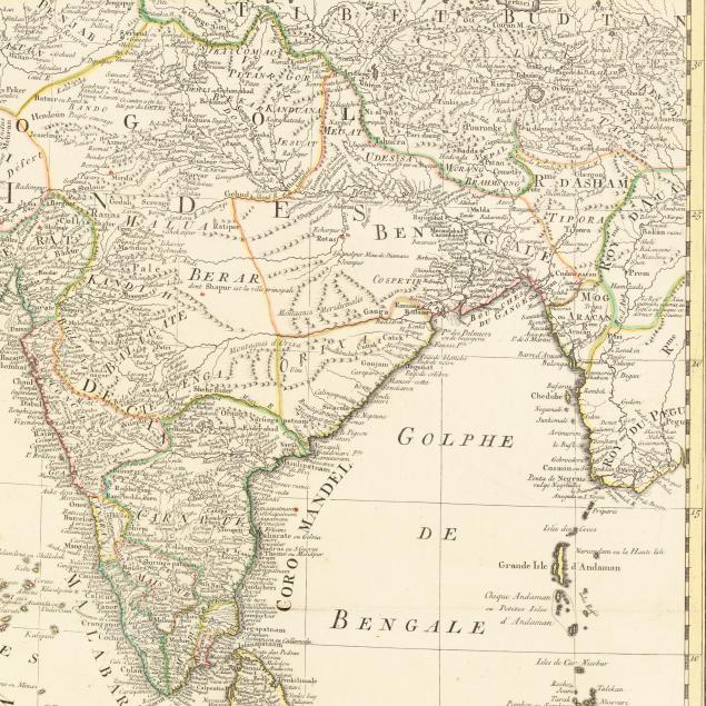
CARTE D'UNE PARTIE DES INDES ORIENTALES, ETATES DU MOGOL LES CÔTES DE MALABAR ET DE COROMANDEL &C. DRESSÉE SUR LES RELATIONS LES PLUS NOUVELLES, circa mid-18th century. Presenting India and environs. Sight size 23 1/2 x 20 1/2 in.; Frame dimensions 29 3/4 x 26 1/2 in. (Light scattered foxing, centerfold with very small area of separation at margin; mat with scattered foxing; not examined outside the frame.)
From the Collection of Priscilla Schavran, Holly Springs, North Carolina